TM 5-818-7
used in conjunction with local experience and locally
due to expansive materials. The stratigraphy and min-
available soil surveys and boring data. The maps dis-
eralogy are key elements in the classification.
cussed in a and b below are generally consistent with
(1) Classification. The soils are classified into
each other and tend to delineate similar areas of
categories of High, Medium, Low, and Nonexpansive
moderately or highly expansive soil.
as shown in figure 2-1. The distribution of expansive
a. Waterways Experiment Station (WES) Map. This
materials is categorized by the geologic unit on the ba-
map, which was prepared for the Federal Highway Ad-
sis of the degree of expansiveness that relates to the
ministration (FHWA), summarizes the areas of the
expected presence of montmorillonite and the fre-
United States, except Alaska and Hawaii, where swell-
quency of occurrence that relates to the amount of clay
ing soil problems are likely to occur (fig. 2-1). The ba-
or shale. The amount refers most significantly to the
sis for classification depends primarily on the esti-
vertical thickness of the geologic unit, but the areal ex-
mated volume change of argillaceous or clayey mate-
tent was also considered in the classification. The
rials within the geologic unit, the presence of mont-
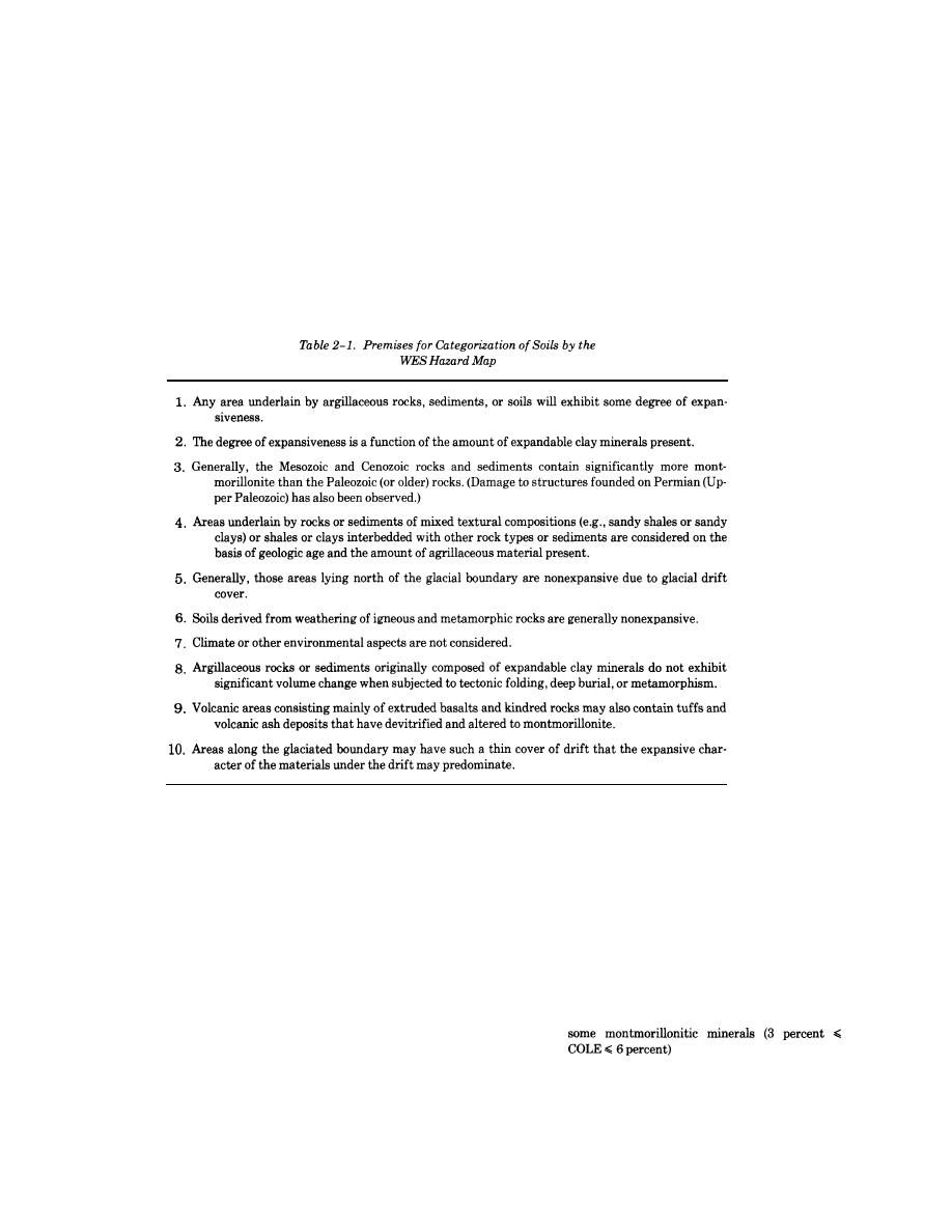
premises in table 2-1 guide the categorization of soils.
morillonite, the geologic age, and reported problems
(2) Physiographic provinces. Table 2-2 summar-
(2) Assessment map of expansive soils within the
izes the potentially expansive geologic units on the ba-
United States. The major categories for classification
sis of the 20 first-order physiographic provinces. Fig-
of the severity of the swelling soil problem presented
ure 2-1 shows the locations of the physiographic prov-
by J. P. Krohn and J. E. Slosson (American Society of
inces.
Civil Engineers, Proceedings of the Fourth Interna-
tional Conference on Expansive Soils, Volume 1 (see
b. Other maps.
app. A) correspond to the following modified shrink-
(1) Area map of susceptible soil expansion prob-
swell categories of the Soil Conservation Service (SCS)
lems. A hazard map was developed by M, W. Witczak
of the U. S. Department of Agriculture:
(Transportation Research Board, Report 132) on the
High:
Soils containing large amounts of montmorillonite
basis of the occurrence and distribution of expansive
and clay (COLE >6 percent)
soils and expansive geologic units, the pedologic analy-
Moderate:
Soils containing moderate amounts of clay with
sis, and climatic data to delineate areas susceptible to
expansion problems. Some geologic units for which
engineering experiences were not available may have
Low:
Soils containing some clay with the clay consist-
ing mostly of kaolinite and/or other low swelling
been omitted, and the significance of pedological soil
clay minerals (COLE <3 percent).
on expansion was not shown on the map.
2-2


 Previous Page
